Different kinds of claim stay different on purpose.
Government and primary institutional records lead. Academic teaching material, archives, and contemporary reference works fill specific transitions. A period source is identified as a period source. A current status is stamped with the date checked. A number retains both its data year and geography.
| Class | What it can support | What it cannot silently become |
|---|---|---|
| Historical record | A sourced event, date, institution, or transition | Legend, total explanation, or unbroken continuity |
| Measured data | A count for a named year and geography | A current estimate under a new label |
| Current status | What an institution or policy page stated when checked | Proof that every older statistic is current |
| Plan estimate | The scale and assumptions of an official framework | A census result or guaranteed outcome |
| Plan proposal | That a scheme or land use is formally named | Funding, construction, completion, or benefit |
| Folklore / tradition | A culturally transmitted account, visibly labelled | Established history without corroboration |
The complete line-by-line source list remains available as SOURCES.md. This page explains the same rules in a more readable form without replacing that detailed record.
Twenty-two entries carry the public argument.
- S01Mehrangarh Museum Trust · history and architecture: Mandore, Rao Jodha, fort growth, capture, alliance, and building phases.Open ↗ (opens in a new tab)
- S02Government of India · Jodhpur Foundation Day: official commemoration of 12 May 1459.Open ↗ (opens in a new tab)
- S03IGNCA · Rajasthan political chronology and 1857: Chandrasen and the Auwa campaign.Open ↗ (opens in a new tab)
- S04IGNOU · Mughal and Rajput States: Jaswant Singh’s succession crisis and Rathore rebellion.Open ↗ (opens in a new tab)
- S05Rajasthan Tourism · Jodhpur: current public identity, water places, Khejarli, Umaid Bhawan, and attractions.Open ↗ (opens in a new tab)
- S06Smithsonian NMAA · Jodhpur treaty of 1818: archival record for the 6 January agreement.Open ↗ (opens in a new tab)
- S07North Western Railway · Jodhpur Division overview: construction, opening, and workshop chronology.Open ↗ (opens in a new tab)
- S08Government records · accession, Greater Rajasthan, and High Court: 1947 separated from 1949.Open ↗ (opens in a new tab)
- S09Mehrangarh Museum Trust · about and museum: trust history and the fort’s present public role.Open ↗ (opens in a new tab)
- S10Rao Jodha Desert Rock Park: 2006 creation, restoration purpose, and approximate 70-hectare extent.Open ↗ (opens in a new tab)
- S11Census of India · A-04: official 2011 Urban Agglomeration, outgrowth, and Municipal Corporation counts.Open ↗ (opens in a new tab)
- S12PIB + Census India · Census 2027 schedule: why houselisting is not a new population count.Open ↗ (opens in a new tab)
- S13Rajasthan Economic Review 2025–26: Jodhpur’s district product and destination positioning.Open ↗ (opens in a new tab)
- S14Rajasthan Tourism · 2024 visit reporting: department-reported visits, not unique identities.Open ↗ (opens in a new tab)
- S15Rajasthan High Court · current principal-seat status.Open ↗ (opens in a new tab)
- S16IIT Jodhpur + AIIMS Jodhpur · current education, research, and healthcare institutions.Open ↗ (opens in a new tab)
- S17Jodhpur Development Authority · Master Development Plan 2031: regional estimate, land, capacity, and proposals.Open plan PDF ↗ (opens in a new tab)
- S18JDA · draft zonal report for Nagar Nigam South: approval record and staged detail-planning evidence.Open ↗ (opens in a new tab)
- S19Rajasthan Heritage Protection and Promotion Authority · Auwa: a commemorative state account of the Jodhpur Legion, Kushal Singh Champawat and the 1857–58 conflict in present-day Pali.Open ↗ (opens in a new tab)
- S20Mehrangarh Museum Trails · Rani Sagar: the Trust's interpretation of Ranisar's name, probable builder and western outwork—not a present-condition report.Open ↗ (opens in a new tab)
- S21Humanities and Social Sciences Communications · 2026 old-city resilience study: participatory research and an attributed expert-interview account of blue-house practice and naming.Open ↗ (opens in a new tab)
- S22University of Ferrara repository · 2019 historical-surfaces record: blue Jodhpur as a material, chromatic and conservation-survey problem.Open ↗ (opens in a new tab)
Read the record without losing the journey.
These government, institutional and specialist teaching PDFs remain with their original publishers. This site does not mirror a file merely to create another copy. It turns a document into a Jodhpur reading edition only when the useful passages, tables, figures, dates, geography and internal contradictions can be explained in accessible HTML.
A finished edition begins with the document’s identity and period, then provides a navigable contents map, page-addressed findings, highlighted decisions, accessible tables, figure descriptions, contradiction notes and a clear link to the original. Automated extraction can assist the work; it never becomes public prose without page-by-page checking.
The official file always opens in a new tab. Internal Jodhpur chapters remain in the current tab, so a reader can consult the primary record without surrendering their place in this guide.
Climatological Information: Jodhpur station 42339, period 1991–2020
India Meteorological Department, Meteorological Centre Jaipur · Government publication · source checked 09 August 2026
Use this source for: Monthly mean daily minimum and maximum temperatures; Monthly mean rainfall and rainy-day counts; Seasonal heat and rainfall comparisons for trip planning.
Do not infer: The table is a 1991–2020 climate normal, not a forecast for a visitor's dates; Station conditions do not describe every street, indoor space, or individual heat response.
Read the official PDF (opens in a new tab)Jodhpur Master Development Plan 2031
Jodhpur Development Authority, Government of Rajasthan · Government publication · source checked 11 August 2026
Use this source for: The official plan's stated baseline years, 2031 regional horizon, land-use vocabulary, infrastructure requirements, and named proposals; A primary record for distinguishing observed data, planning estimates, planning standards, and proposals.
Do not infer: The plan does not prove present delivery, funding, construction, completion, benefit, or the current legal status of every detailed proposal; Its regional forecasts, older baseline tables, and mapped planning areas cannot be relabelled as a current city population or present administrative geography.
Read the official PDF (opens in a new tab)AIIMS Jodhpur Annual Report 2023–24
All India Institute of Medical Sciences Jodhpur · Institutional publication · source checked 11 August 2026
Use this source for: The institution's own account of its 2023–24 education, research, clinical, administrative, and public-health activity; A dated primary source for developing a bounded institutional profile.
Do not infer: An annual report describes a named reporting period and cannot establish today's department, appointment, bed, service, staff, research, or emergency status; Institutional reporting is not independent clinical evaluation and cannot support personal medical advice.
Read the official PDF (opens in a new tab)Rajasthan Economic Review 2025–26
Finance Department, Government of Rajasthan · Government publication · source checked 11 August 2026
Use this source for: State reporting and policy context for Jodhpur-linked programmes, products, destinations, sectors, and public investment; The Panch Gaurav identification of wooden furniture as Jodhpur's district product and Mehrangarh as its selected tourist destination.
Do not infer: A programme designation is not a complete economic census, quality mark, origin guarantee, employment count, export result, or endorsement of a business; Every extracted number requires its own table year, unit, scope, and geography.
Read the official PDF (opens in a new tab)Rajasthan Tourism coverage report using 2024 visit data
Department of Tourism, Government of Rajasthan · Government publication · source checked 11 August 2026
Use this source for: Department-reported domestic and foreign tourist-visit counts for Jodhpur City in 2024; A dated public series for discussing reported tourism scale.
Do not infer: Visits are not necessarily unique people, booked stays, ticketed monument entries, revenue, satisfaction, local benefit, or current demand; The report cannot support a forecast or a claim about one neighbourhood, operator, season, or visitor segment without further evidence.
Read the official PDF (opens in a new tab)Jodhpur district aquifer mapping and management plan
Central Ground Water Board · Government publication · source checked 11 August 2026
Use this source for: A government hydrogeological account, aquifer framework, groundwater observations, quality context, and management proposals for the report's stated Jodhpur geography and period; A primary basis for separating aquifer evidence from heritage-water and municipal-supply narratives.
Do not infer: The report's date and former district geography must remain visible after later administrative boundary changes; Regional groundwater information cannot establish the safety, yield, depth, ownership, legality, or current condition of an individual well or household supply.
Read the official PDF (opens in a new tab)District Industrial Profile of Jodhpur
Development Commissioner, Ministry of Micro, Small and Medium Enterprises · Government publication · source checked 11 August 2026
Use this source for: A dated government baseline for industrial areas, resources, enterprises, employment, clusters, infrastructure, and identified sectors in the report's Jodhpur district geography; Historic evidence that furniture, handicraft, guar, steel, stone, textile, and other sectors were institutionally recorded.
Do not infer: The profile is old and predates later district changes; its counts, units, employment, production, problems, and opportunities are not current facts; It does not establish that a named unit is operating, compliant, representative, safe, profitable, export-active, or suitable for a visitor.
Read the official PDF (opens in a new tab)Export Promotion Council for Handicrafts Annual Report 2024–25
Export Promotion Council for Handicrafts · Institutional publication · source checked 11 August 2026
Use this source for: The Council's account of 2024–25 programmes, trade promotion, fairs, facilities, training, policy work, and Jodhpur-linked handicraft and furniture activity; A dated primary institutional source for the formal export-promotion layer.
Do not infer: Council reporting does not describe every artisan, worker, firm, informal market, buyer, order, export, labour condition, or local benefit; Event participation, programme activity, and sector promotion are not proof of commercial success, product provenance, quality, or present availability.
Read the official PDF (opens in a new tab)Census of India houselisting operations schedule for Rajasthan, 2026
Office of the Registrar General and Census Commissioner, India · Government publication · source checked 09 August 2026
Use this source for: The Census authority's published 2026 houselisting schedule for Rajasthan; A primary operational source for separating houselisting activity from the later population enumeration.
Do not infer: A houselisting schedule is not a new population count, demographic estimate, district total, or completed census result; The document does not establish that every scheduled operation occurred unchanged; later official notices control.
Read the official PDF (opens in a new tab)Rajasthan e-Mitra Local Service Provider request for proposal, 2025
Department of Information Technology and Communication, Government of Rajasthan · Government publication · source checked 09 August 2026
Use this source for: The document's dated operational reference to Rajasthan's 41 districts and seven divisions; Evidence that Phalodi was treated separately from Jodhpur in the cited 2025 administrative context.
Do not infer: A procurement document is not a permanent boundary gazette or a complete account of later administrative change; Older Jodhpur district data cannot be silently restated for the later geography, and the live district list still requires checking.
Read the official PDF (opens in a new tab)History of the Rajasthan High Court
Rajasthan High Court · Institutional publication · source checked 09 August 2026
Use this source for: The Court's institutional account of its 1949 inauguration and later constitutional development; A primary institutional source for keeping Jodhpur's judicial history distinct from accession and state integration.
Do not infer: Institutional history is not a substitute for the underlying constitutional instruments, statutes, judgments, or gazette records; It does not establish current filing rules, bench listings, case status, jurisdiction for a specific matter, or legal advice.
Read the official PDF (opens in a new tab)Jodhpur Master Development Plan 2031 proposed land-use plan
Jodhpur Development Authority, Government of Rajasthan · Government publication · source checked 09 August 2026
Use this source for: The official draft map's proposed land-use categories and mapped planning extent for the 2031 framework; A primary visual source to compare with the plan report's U1, U2, U3, corridor, rural, water, hill, forest, reserve, and other categories.
Do not infer: A draft proposed map is not proof of present land use, parcel-level status, legal entitlement, acquisition, funding, construction, or completion; The site's procedural rings and paths are explanatory graphics and do not reproduce this map or its boundaries.
Read the official PDF (opens in a new tab)State of Environment Report for Rajasthan 2009
Ministry of Environment and Forests, Government of India (document host) · Government publication · source checked 09 August 2026
Use this source for: The report's official environmental context and its account of the 1730 Khejarli sacrifice; A dated government source used alongside Rajasthan Tourism for the site's bounded Khejarli reference.
Do not infer: A 2009 state report does not establish current ecological condition, community circumstances, species status, land use, or conservation outcome; Its historical summary is not a complete primary-source reconstruction of every person, number, event, or later interpretation.
Read the official PDF (opens in a new tab)Overview of Jodhpur Division
North Western Railway, Indian Railways · Government publication · source checked 09 August 2026
Use this source for: The railway administration's chronology of construction beginning in 1881, the first section opening in 1882, and the Jodhpur workshop following in 1886; A primary institutional baseline for Jodhpur's railway-era transition.
Do not infer: A division overview is not a complete railway history and may not resolve every route, gauge, administration, merger, or workshop change; It cannot support current train schedules, fares, platform assignments, service quality, accessibility, or journey-time advice.
Read the official PDF (opens in a new tab)Mughal and Rajput States, Unit 11
Indira Gandhi National Open University · Specialist teaching publication · source checked 09 August 2026
Use this source for: A specialist teaching synthesis of Jaswant Singh's succession crisis, Ajit Singh's posthumous birth, and the Rathore rebellion; Context for presenting Mughal-Marwar relations as changing political negotiation rather than one unbroken condition.
Do not infer: A teaching unit is a secondary synthesis, not the original court, administrative, epigraphic, manuscript, or material record; It cannot by itself settle contested motives, exact chronology, social experience, or every interpretation of the conflict.
Read the official PDF (opens in a new tab)Draft Zonal Development Plan for Nagar Nigam South, Jodhpur
Jodhpur Development Authority, Government of Rajasthan · Government publication · source checked 09 August 2026
Use this source for: The report's account of the Master Development Plan approval and the role of zonal plans in detailing and phasing that framework; Evidence that JDA publishes later, more detailed planning material whose document state and date must remain visible.
Do not infer: A document labelled draft does not establish final approval, current legal force, parcel-level status, implementation, funding, construction, completion, or benefit; It cannot show that every Master Plan proposal has progressed or that no later plan, notice, amendment, or court decision controls.
Read the official PDF (opens in a new tab)What is withheld matters as much as what is printed.
- Hermit curses, live burial, and Karni Mata foundation accounts remain labelled tradition or folklore.
- Solar descent and direct descent from Kannauj’s rulers are not treated as established genealogy.
- Mehrangarh was not “completed in 1459,” was captured in 1544, and is not presented as permanently unconquered.
- Mughal–Marwar relations are not reduced to one oppression-versus-resistance story.
- No exact August 1947 accession day or sensational “blank sheet” story is asserted without the original signed instrument.
- No single caste, cooling, termite, or other explanation for blue-painted houses is declared definitive.
- No claim that Jodhpur adopted blue paint only in the late twentieth century is made. Surface practice, wider adoption, film-linked repainting and public naming require separate evidence.
- No ranking of the Jodhpur Railway Workshop as one of “South India’s most important” workshops is repeated; the geography and superlative are unsupported by the checked railway records.
- Khejarli is not labelled the world’s oldest environmental movement or the first Chipko movement. Its 1730 Bishnoi-community history is retained without an unsupported superlative.
- A historical outwork at Ranisar is not relabelled as present fencing, and no current lake access, water-level, water-quality, safety or utility condition is inferred from heritage copy or an old photograph.
- No “2026 population,” current second-largest-city rank, tourism unique-visitor total, or unsupported superlative is invented.
- The 3.1 million 2031 value remains a wider-region plan estimate, not a future city census.
- No special scheme is called funded, built, complete, or beneficial without project-level implementation evidence.
- No master-plan colour, broker statement, listing, brochure or construction image is treated as parcel title, permitted use, approval, servicing, market value or investment advice.
Jodhpur is the city and former capital. Marwar is the wider region and historical polity. The site never treats those categories as interchangeable.
Real photographs. Visible creators. No invented past.
All local photographs are resized WebP adaptations for web delivery. CSS may crop or colour-treat them at display time. No historical person, battle, street, or architectural state is generated and presented as documentary evidence.
| Subject | Creator | Licence | Source |
|---|---|---|---|
| Mehrangarh, city and Ranisar | Dlinemedia | CC BY-SA 4.0 | Commons (opens in a new tab) |
| Rao Jodha statue and fort | Sreesarkar | CC BY-SA 4.0 | Commons (opens in a new tab) |
| Mandore Gardens | Surbhighoghari | CC BY-SA 4.0 | Commons (opens in a new tab) |
| Blue City panorama | Lokankara | CC BY-SA 3.0 | Commons (opens in a new tab) |
| Phool Mahal | Dinesh Valke | CC BY-SA 2.0 | Commons (opens in a new tab) |
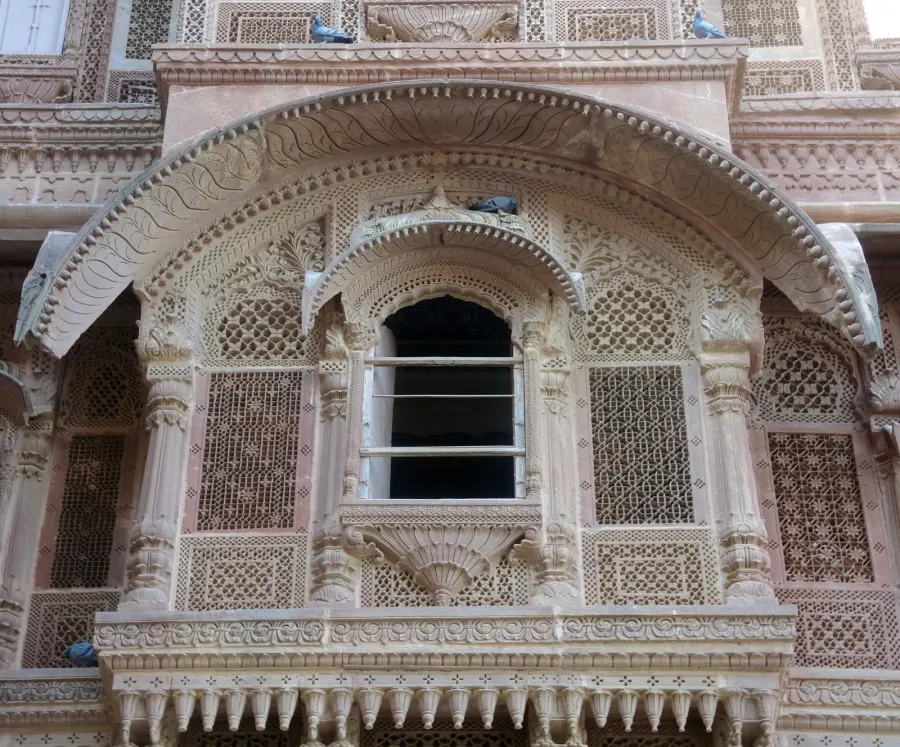
| Mehrangarh jharokha | Güldem Üstün | CC BY 2.0 | Commons (opens in a new tab) |
| Jaswant Thada | Kumaranshu26 | CC BY-SA 4.0 | Commons (opens in a new tab) |
| Umaid Bhawan | Yann Forget | CC BY-SA 4.0 | Commons (opens in a new tab) |
| Ghanta Ghar | Vyacheslav Argenberg | CC BY 4.0 | Commons (opens in a new tab) |
| Sardar Market | Güldem Üstün | CC BY 2.0 | Commons (opens in a new tab) |
| Toorji Ka Jhalra | Dr. Raju Kasambe | CC BY-SA 4.0 | Commons (opens in a new tab) |
| Ranisar Lake | Jakub Hałun | CC BY-SA 4.0 | Commons (opens in a new tab) |
Share-alike terms apply to adapted photographs carrying CC BY-SA; they do not automatically relicense unrelated original prose or code. Market images are used editorially; no subject endorsement is implied.
The 3D layer is an argument—not a map.
The flagship’s ridge → fort → water → city → living Jodhpur → 2031 → continuum relief is original procedural composition. It is not GIS, archaeology, a fort plan, a measured street map, an official land-use reproduction, or a reconstruction of Jodhpur at any historical date.
Terrain heights, walls, water shapes, camera positions, buildings, rings, corridors, paths, and nodes are authored explanatory geometry. Seeds 1459 and 2031 are mnemonic numbers, not dataset identifiers. Continuum paths do not represent roads, rails, pipes, boundaries, migration, causation, or implementation.
The real claim is narrower: sourced records support the relationships among elevation, fortification, water infrastructure, urban accumulation, current institutions, and a formal regional planning framework. The abstract composition makes those relationships visible while its caption and this page state exactly what it cannot prove.
Return to the seven-stage relief →